 Live Music Archive
 Librivox Free Audio
 Metropolitan Museum
 Cleveland Museum of Art
 Internet Arcade
 Console Living Room
 Books to Borrow
 Open Library
 TV News
 Understanding 9/11
tv 9 News Now at 11pm CBS October 29, 2012 11:00pm-11:35pm EDT
11:00 pm

. historic weather day rolling into a historic weather night. >> sandy is making landfall and it's battering new york city. the super storm sent water rushing into the street and thousands are without power and we got thousands without power here in our area, a lot of cancellations tomorrow. tonight 9 news has crews bringing you the latest to keep
11:01 pm
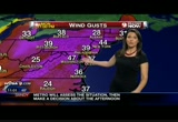
you and your family safe. first, the latest. >> good news. the winds will not be as strong as we thought, that's the good news but the bad news is they will be persistent into early on tuesday. so some good news there. maximum wind 60-miles per hour so far and 90-mile per hour in long island. for more on winds, here is erica. >> yeah, the winds are strong but they have subsided a little bit since the last time we were with you. 47 miles per hour is the current peak wind gust. 37 in ocean city and 39 in philadelphia. 36 in norfolk where we are expecting those winds to get a little bit lighter in the norfolk area but in the dc metro, we're expecting these winds to continue to gust between 40 and 60 miles per hour as we head through the overnight hours. right thousand we're at 48 in baltimore and same martins burg and 60 still in wind chester
11:02 pm
where we're getting down sloping helping to increase the wind speed. the winds are gusting at 41 right now and 43 in packs river and there is a huge scope where the winds are at this level, this tropical storm force level 40 or greater and it's 400 miles around the center of the storm and you can see the center there as a donut hole of relatively low wind speed s and as this storm continues to slowly make it's way across maryland, we'll see the winds continue as well. >> again, some good news, the winds not as strong as we thought but they will be persiste and continue into tuesday morning. check out these wind speeds already. maryland 67-miles per hour and new hampshire avenue 70 and morning side 54 and virginia 50-mile per hour and our friends in percyville a 60-mile per
11:03 pm
hour wind gust. by 1:00 a.m. notice no longer does the hurricane forced winds enter into the metro or even into the bay for that matter. yes, we still have to contend with the orange color 58 miles per hour to 70 but that's better than the red. so right now 7:00 in the morning we'll see most of the metro area with, again, a strong shot of winds 58 to 68, maybe 70 at daybreak tomorrow at 7:00. but then some good news, this goes away pretty quickly. again, the bad news, the scope of tropical force winds over 39 miles per hour extending south of norfolk up 95 to hartford connecticut. a massive storm will continue even though this is 3:00 in the afternoon on tuesday. the hang tough for awhile even at this hour, neck -- tomorrow about 23 hours from now we have tropical storm force winds and
11:04 pm
by halloween, 6:00 in the morning the winds will be out of here and we can take a breathe. so stay away from windows tonight. if you go to bed, go to bed on a lower level because the highest winds will happen overnight and very early tomorrow morning. we'll keep the highest winds at 40 to 75-mile per hour wind gust not out of the question. critical time new until 2:00 p.m. on tuesday. again, the winds will not stop at 2:00 p.m. but more manageable. look at the radar, last patch of really heavy rain pushing through the western suburbs and this was a tremendous area. some areas with that bach between 6:00 p.m. and now picked up 4 inches of rain. we'll zoom in. heaviest rain pulling out of fair fax counties moving into prince william and all going to move off to the south and the west moving through and in fact, very heavy rain and out 17 over out 66 as well over towards the
11:05 pm

san doe what. that's where the heaviest rain is now. after that goes through, our heaviest rain will subside somewhat, not going to clear out but the real flooding problem will subside. maryland 4 inches of rain and bowie 5 and fair fox 3 and alexandria 2 inches and gerrsrdstown4 inches. the heavy rain will taper off and the highest winds have come down but the highest yet to come overnight and very early on tuesday. back to you. >> all right. comprehensive warning of what to expect. >> but seeing the pictures in new york city you feel like we may have dodged a bullet. still, several streets had to be evacuated, folks on fen wick and arlington they were told back at 5:30 grab three days worth of stuff and get out. the power is shut off there.
11:06 pm

debra has been in the neighborhood throughout the evening. did everybody go and move to a red cross shelter where you are now? >> reporter: actually not everyone did come to this shelter, but there are people -- we're at the lee district rec center. some people had friends they went to see or family they went to see in different parts but what happened is, what i want to show you why they need to get out. let's show this. you can see this body of water, that's the cameron run hunting creek. look at this, fen wick drive comes up to it and that water will come over it and this street here if i can get in there and show you, you can see also arlington terrice right there that's another place where they need to get out. they are over there and we were there before the firefighters and cops and telling people to get out and i could tell you this, we met one nice family and they had two young kids, one
11:07 pm

who was extremely happy to see us. >> i'm on tv, yeah. >> reporter: mandatory evacuations, two words that mean next to nothing to these two kids. there is a mandatory evacuation on this road. >> i didn't know. so yeah, no, we got some information to our newsroom so we're here to see what everybody is doing but you don't know. >> i didn't hear about it. last time they came by and knocked on the door. >> reporter: 9 news beat the fire crews to the streets. where are you going to go? >> right now we'll probably go to a hotel. >> september we get it so up to here so that's why you got it and this time double. >> reporter: did you lose anything last time? >> yes, a lot. >> reporter: what kind of stuff did you lose? >> the microwave, you know.
11:08 pm

>> reporter: and that family is excited to get out of there because actually the two kids are excited because they are promised they would go to a hotel with a pool. back here we want to find out more. michael hunter, you are the manager, why is it so important for people to know about shelters like this? >> red cross is here to help people recover and deal with what is going on. power outages as the storm goes through and a place to come, sleep, become fortable and a place to live until things get back to normal. >> what should people bring with them? that's an important question. >> change of clothes, couple of pairs change of clothes, any personal items very personal, dentures, medicine that you might need, baby formula, baby diapers, those things, we can get some but if you have some to get started before we get the full mass here, that helps. anything comfortable like you
11:09 pm

like a blanket, teddy bear. >> what about pets? >> we do take pets here. they are working with us. their have a facility here with us outside the building to shelter the pets. >> thank you so much. we appreciate that. we're at 6601 telegraph road. there is a number (571)350- 1300. that the the emergency hot line which is 24/7. thank you for the hard work you do and we appreciate that. that's the latest from here. >> thank you debra. appreciate that. talk about a friend in need. >> exactly. >> to video just in, it's flooding along rhode island avenue in northeast dc. some folks were probably expecting this. flooding in that part of town is a real problem in recent months. any time there is a heavy rain that neighborhood gets flooded with water backing up into many homes there, city crews are making a point of clearing out the storm drains and the major
11:10 pm

talked about this area and visited it. >> but if there was one thing people were worried about, it is the lights going out, power outages,. we are following that story and via the web he can tell us who is out and who is not. >> we're approaching a half million people. you can look at that number 480,000, you can compare that to 29 minutes earlier at 431,000 and i got a quote from a spokeswoman who spoke to -- you were talking about earlier is pepco's numbers -- the spokeswoman saying the low outage numbers are not what they expected, either. we've been very fortunate saying crews will repair when safe. let's look at the numbers on the big ones, bge, edison 51, 524
11:11 pm

and pepco at 40,304 and look at the maps, first we'll start with pepco and you can see the blue outline so these splotches of color indicate the areas that are having power outages and you can see that's everyone except for you lucky folks right there but really the numbers considering the amount of customers they serve at 38,000 that is much less than folks would have expected even the folks at pepco. bge approaching 200,000 people without power and that's their map. you can see buoy, laurel, columbia past baltimore you can see 48,889 customers without power. and we're going to move over
11:12 pm

here to novek reporting 25,000 out of power. we'll zoom in on the area on that one find out what we can in that area. we'll pick that one right there. and you can zoom in on these and we know this one was reported at 1:44 and as of the case with a lot of these they don't know what caused it. look at edison and this is something that has been building upright now over 50,000 customers without power. you look at the county, 5000, carol county 1300 but frederick county maryland that i'm hearing from a lot of you, 26,000 customers without power and they have a few in montgomery about 2600 and we're going to take one quick look and reporting they are -- their totals -- and now we're not seeing a total
11:13 pm

right there but one last look at bge and you're going to realize this is where we see the big numbers approaching 200,000 and in our area northern virginia hit hard. that's daminon and pepco lower. >> thank you. >> we were hearing from a spokesperson they have gotten socked and are waiting for heavy winds to die down so they can get to work. >> talk about somebody whose been buffeted by heavy winds all night. ryan dean, ryan? >> you know, it is starting to die down. looks windy here but compared to what it was a few hours ago, we're seeing a lull in the wind and a lull in the rain and i can tell you about 81 people actually went to a shelter at the local high school to seek shelter and then we took a drive up to north beach about a mile and a half from here and roads flooded basically from the board walk on and had roads that had
11:14 pm

been shut down there. the folks in that area say it floods quite commonly when they have storms but again, those roads are shut down. as for the power, we're told there are 2000 at one time in this area, that was earlier today, trees and power lines but we're told 500 people in the area so some folks are having their power restored. here at the resort that we're at, the most people staying here are locals and the reason they came here their home is next to big trees, they did not want to stay there so they are seeking shelter at this hotel. that's the latist here, i'm ryan deed 9 news. >> good to see winds die down there. >> we want to get closer to home. bruce we're told you are not alone. >> no matter how many times reporters and authorities warn folks, there are people that are just absolutely fascinated by
11:15 pm

these storms. in fact, look at the reporters who are out. we're here with a bunch of students who george town, too, who could not resist coming out. why the heck are you out here? >> you know, all the reports coming in from ocean city, we figured we would check it out. >> what do you think? >> i think it was blown out of proportion. it's not that big of a deal. >> as you look around and see rock creek over here and the rain, what do you think? >> i honestly think it's hype that's too high. i'm from houston texas to we seen the water rise. >> you've seen hurricanes hit houston. >> again and again, so nothing new. >> and the georgetown will have a different prospective than that. >> ironically i'm from maryland so for me this is exciting because the last time we had a big hurricane was irene and it
11:16 pm

was blown out of proportion as well. this one may be a little stronger but. >> irene i'll tell you what did a lot of damage in different places and the reality here -- thanks a lot, folks, the reality here is that a little bit of waiverring can make a huge, huge difference and you can see as time goes on, it can also make a big difference. you can come over and look at the patomic and rock creek is high and as that water comes down out of the mountains, there is serious potential for flooding. let's take it back to you. bruce live in foggy bottom. found himself company, folks that tend to think the hurricane is over blown, fact is, if you look up the street in some of the neighbors and farther up the road in new york city, they will tell you this was not over blown and a complete disaster. >> thank you. we'll check in with topper but this thing is speeding up and
11:17 pm

making landfall there near atlantic city and then going inward toward philadelphia, toward new york city and causing terrible damage. we really did luck out in someways. >> someways, at least so far. we'll show you pictures that will make you realize how lucky we've been. >> joining us now on the telephone, judy peterson with fair fax county government. what is the situation there regarding flooding, power outages and concerns in fair fax? >> let me tell you we wanted to make sure residents of the bellevue new alexandria area knew we were reaching out by phone to make them ready for the possibility of flooding in their neighborhood tomorrow afternoon or evening. this message is for people that live east of the road. west of george washington parkway, south of bell haven road and north of wake forest drive. that this is the area that the county is concerned about that
11:18 pm

engine nears are monitoring the situation there. should this escalate and again, this would be tomorrow. if flooding was imminent and an evacuation was required, these folks would be called and the public safety personnel would be knocking on the door. >> we have been told earlier in the evening that 23 local roads have been closed in fair fax. does that number stand? are some of those reopened or more roads shut down? >> ire don't have a number of roads which are closed at this time. actually, i do now. that is 38 roads and we are keeping track of them and we are posting them and updating it hourly. >> judy, your engine nears are talking about flooding late tomorrow. why that time frame? >> i believe that it has to do with the tide, i believe it has to do with the amount of rain.
11:19 pm

there's a variety of different factors. i don't know that i could give you the specifics but i can tell you that we have had the engine nears looking into the situation very concerned and believe those would be the times which would be most threatening. >> we've got a couple meteorologists around here and we'll ask them about it but in terms of traffic and intersections, how many lights are out and how much of a problem do you expect that to be? >> well, all of the status for the lights that are out and of those things would probably be information that the police department would have and the department of transportation and i would be glad to get back with you but i'm afraid i don't have those at my fingertips now. >> i understand. >> judy, one last thing, we were hearing that some of the same areas you're talking about that outages have been quite extensive in fair fax county. can you give us any idea on
11:20 pm

that and in particular there seem to be large groupings of outages in the alexandria area. >> the outages in the alexandria area? you have to check with the virginia power and with novac. they have that information online and because it keeps changing i don't want to give you particular numbers. you would be best served going to their websites or our emergency blog or call our information hot line and that would be at (571)350-1300. >> judy peterson with the fair fax county government. we know it's a busy night and the information is changing quickly and you're doing your best. >> sounds like some people will be getting calls if there is a belief that their home in their particular neighborhood is in
11:21 pm

danger of flooding tomorrow and this water may come in. >> interesting to know when we talked earlier, 23 roads have been shut and the number is up to 38 and will grow further and if the floods come through, it could be worse than that. our facebook page is a great place to get information for pictures, commits, trying to get answers. 9 news will be back with special coverage after the break.

11:23 pm

new york city taking quite a beating. >> when you see the pictures we're talking about, you know not only have we dodged a bullet but this was not over hyped.
11:24 pm
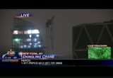
depends where it ended up. so we spent the evening gathering video and all that's coming out in other parts of the northeast. >> derrick and anita, we're hearing ten confirmed deaths in this area. new york city and new york state and the new jersey area so never a not over hyped at all. concern tonight in new york city about a crane dangling 75 stories above the street. check this out, this is a live picture in new york city. sandy's winds partially ripped the crane off the side of an unfinished skyscraper and you can see it swing back and forth. emergency responders have closed off part of the street. people in nearby buildings have been evacuated, a very dangerous situation there. >> really unknown as to how the crane got to where it was. it flipped over and the boom flipped over but the whole area has been evacuated and cleared. no traffic on the street, below it, the steam pipes are being
11:25 pm

turned off. all of the gas lines have been, you know, made certain they aren't having gas go through them. if it land the on the sidewalk, it won't cause an explosion or fire. >> new york city mayor bloomberg says he's instructed everyone on the scene don't try to be a hero and lose a life over this. here is another unusual sight, the skyline of new york is pretty dark tonight. more than 156,000 customers are without power. they had to pull the plug on 6000 homes in lower manhattan because the storm surge threatened to flood the delivery system. the utility also cut service to 140 customers in manhattan fearing that the steam pipes could explode if indicated with cold water. more great video out of new york. the building in chelsea crumbled to the ground and check it out,
11:26 pm
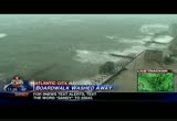
the damage exposed four apartments to the elements and to onlookers. emergency vehicles are on the scene with the red cross. no injuries luckily were reported and it collapsed according to authorities, the debris hit a car on the street below. no one was home at the time of the collapse. hurricane sandy or should we say downgraded know washed away part of the atlantic city board walk. this is video shot before it got dark. at least 6 to 8 blocks of the famous board walk were pounded to pieces by a relentless and powerful surf and look at this video of water rushing across the street in atlantic city. can you see it? definitely dangerous out there. that's the big surge. there is part of the board walk there. our coverage of sandy continues after the break. stay with us.


11:29 pm

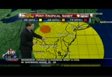
welcome back to 9 news continuing coverage. here is where we stand now. after making landfall along southern new jersey sandy is now flooding parts of new york's
11:30 pm

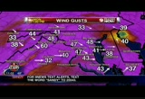
lower man matten. the storm is blamed for ten deaths and knocked out power to 3 million people up and down the east coast. >> staggering numbers. here we're in for strong winds and heavy rain through the night. the federal government and many local governments and school systems closed once again tomorrow. metro shut down at least through tomorrow morning's commute. you'll find the latest chancelations at w usa 9.com. as we've been looking at this thing down the east coast the sense is that new york got the worse of it. are we correct? >> they had less rain than we had and more wind and they are not done with the storm but some wind ironically were higher. in fact, a 75-mile per hour wind guest and jfk74 and wind gusts at laguardia 90. let's start with the softer side. this is the cold side. there is snow, this came through and they will have about
11:31 pm
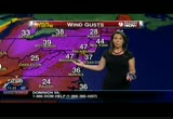
8 inches on the ground tomorrow morning. this is sent to us by lorrie and looks like snow shoe will have a foot to 4 inches on the ground by morning and snow all day. for more on winds because we're not done yet, here is a look at winds with erica. >> thanks top. we have strong wind gusts now. i did see a report on the national weather service website the peak wind gust at ragen international is 60. this is saying 47. so either way, it's tropical storm force. same deal in philadelphia 47 miles per hour and 37 in ocean city new jersey. the center of the storm is just to the south of philadelphia and you can see the area where the winds are light but wrapped around that we have the very strong winds and of course since this system has winds that go counter clockwise, you have the winds coming out of the west and northwest on that side of the storm. so we have 49-mile an hour wind
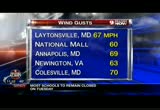
11:32 pm
gusts right now an andrews, 54 and 41 in baltimore so we're not done with the winds from this storm. buzz we did have some even stronger wind guests earlier on in the evening and here is a look at some of those. maryland 67 miles per hour and at the national mall downtown in dc60 miles an hour was the peak wind guest, almost 70 for the peak in annapolis and colesville with a 70-mile an hour wind gust. so strong winds and what about the rain, top? >> impressive with the wind so far. here is a look. the good news is the hurricane force winds, the red has gone down a bit however, we still have other wind to contend with, tropical forest winds for sometime and by 1:00 a.m.
11:33 pm

sol stronger winds will be back into the northeast counties and maybe georgia county and baltimore and those winds could be 59 to 70 and then we go through the morning by 8:00 in the morning it could be another round of significant winds. in fact, it's possible that some of these gusts could top the gusts so far and that list we just showed you from philadelphia down through dc all the way in fact all the way to points to the south almost to fredericksburg 59 to 70-miles per hour. we're not done with the storm and tropical storm forced winds through tomorrow afternoon. winds 39, 40 up to 50 and then finally, we get to 10:00 tomorrow and the winds start to be -- start to lift northward and looking at by halloween, the tropical storm forced wind the will be gone but breezy. temperature-wise cool, 45 and 45 downtown you jump the divide
11:34 pm

it's 30 in oakland and snowing to beat the fan there and will continue to do so all day tomorrow and tomorrow night. so stay away from windows. we'll tell you again sleep on the lower level tonight, please, because of the possible stronger winds overnight and winds gradually weaken on tuesday and we mean gradually so by the end of the day, we might be looking at 30-mile per hour winds as opposed to 40 or 50. expect dangerous winds through the noon hour on wednesday. rainfall, reports of 7 inches in grant county and as much as 6 to 7s in loud and i believe that. the good news is the real heavy bands are pretty much done. the bad news is we won't clear out. bands of rain and showers and not quite as intention during the day and heavy bands through fair fax and just to the south on 66. so again, tomorrow will be--
182 Views
IN COLLECTIONS
WUSA (CBS) Television Archive
  Television Archive News Search Service
Uploaded by TV Archive on
